


Guides and Help for the AOI Tool for the Resilience Report
- Resilience Report – User Guide (2025)
- Resilience Report – Quick Guide (2025)
- Recorded Training Webinar – December 2025
About the Resilience Report
The nation’s transportation systems are facing significant threats from the impacts of climate change, in particular from increasing heat, coastal flooding and sea level rise, and heavy precipitation. To protect against the most severe impacts of climate change, data regarding future conditions and climate extremes must be incorporated into the transportation planning, design, and construction process. The goal of this project was to build a tool to mainstream such data and information into the transportation planning process.
The GeoPlan Center developed the Resilience Report as an online screening tool to systematically and rapidly conduct hazard vulnerability assessments for transportation projects. The Resilience Report summarizes and displays analyses of current and future hazard exposure for a user-specified area of interest (AOI) anywhere in the State of Florida, though the majority of the current data is coastal flooding. This tool, original deveoped in 2023 and updated in 2025, assists FDOT and its local and regional partners as they prepare the transportation system for the impacts of climate change.
This project builds off of two ongoing collaborative projects of the GeoPlan Center and the Florida Department of Transportation (FDOT). The Environmental Screening Tool (EST) is a web application that facilitates the evaluation of potential impacts to human, natural, and cultural resources from proposed transportation projects. The Sea Level Scenario Sketch Planning Tool (“Sketch Tool”) is an online geospatial tool for evaluating transportation asset exposure to current flooding and future SLR. The Sketch Tool provides planning-level analyses, but does not allow for project-level scoping and has only limited datasets. This project sought to leverage the strengths of these two tools to facilitate project level screening for flood exposure and assist transportation professionals with resilience decision making.
The Resilience Report version 2 currently includes the following data (metadata for the layers are included in the user guide):
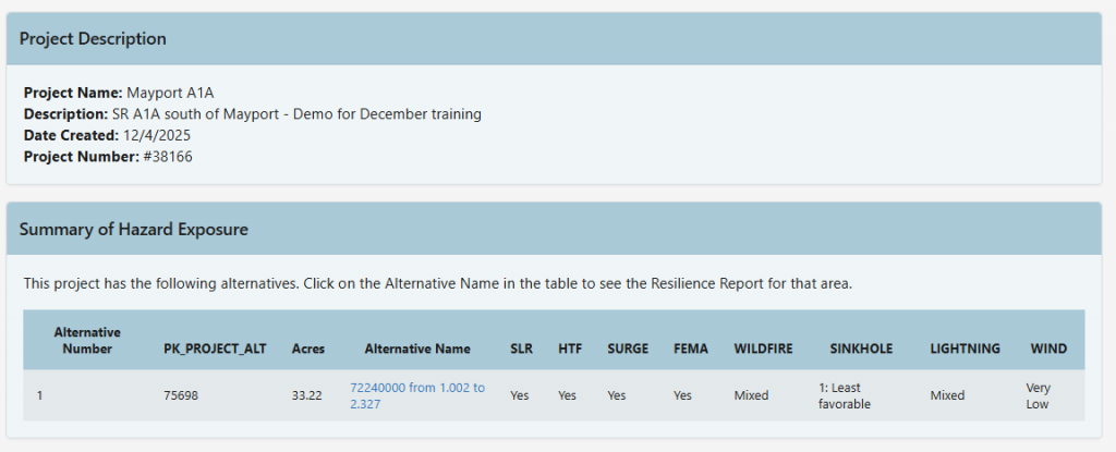
- Coastal and Inland Flooding:
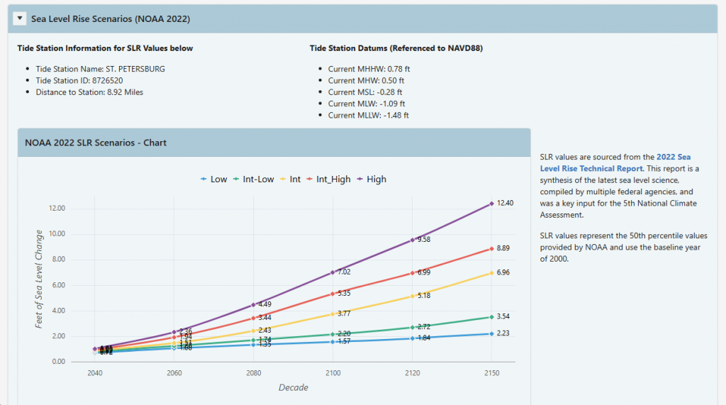
- Sea Level Rise: NOAA 2022 SLR scenarios, 0.5 feet to 10 feet above MHHW
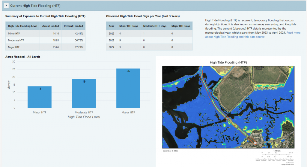
- High Tide Flooding (HTF) – Three datasets showing spatial extent of minor, moderate and major HTF
- One dataset indicating the number of projected days of annual minor HTF under SLR scenarios
- Storm Surge: SLOSH model outputs for hurricane categories 1-5
- Flood Hazard Areas: Federal Emergency Management Agency (FEMA) special and moderate flood hazard areas from the national flood hazard layer
- Non-Flood Hazards
- Extreme Heat – Projected Days over 95 degrees F
- Wildfire Ignition Risk
- Severe Thunderstorm Risk (Lightning and Strong Winds)
- Sinkhole Risk
The Resilience Report is requested through the EST Map Viewer’s AOI Tool, which requires users to have an EST account with AOI access. Once logged into the EST, a user can draw on the map their desired area for analysis (either point, line, or polygon) using the AOI Tool. After submitting basic information and drawing one or more alternatives (features), the user can request a “Resilience Report”. Once requested, automated database processes run spatial overlays of each flood layer with the AOI, which takes approximately 1-3 minutes. After the analyses are complete, the AOI Tool will display a link to the results page.
The benefits of this project include streamlined access to resilience and flooding data for better screening of potential impacts and better project scoping. The Resilience Report can assist in data gathering for PD&E and/or corridor studies and can provide resilience screening for LRTP projects. The Resilience Report could also be used to identify areas in need of more refined analysis (e.g. engineering-level studies). This project supports FDOT’s Resiliency Policy 000-525-053 by developing geospatial tools to facilitate the identification of risks related to SLR, flooding, and storms and assessment of potential impacts.
Requesting Access to AOI Tool for the Resilience Report:
For FDOT staff or consultants with FDOT IT accounts:
- District users request access through your FDOT District ETDM Coordinator
- Central Office users request through Statewide ETDM Coordinator or contact ETDM Help Desk (help@fla-etat.org)
- Once approved by ETDM Coordinator, submit an AARF selecting the EST – AOI Only application
For MPO and FDOT consultants without FDOT IT accounts:
- Request access through your MPO or FDOT Project Manager
- Your Project Manager can then request through the appropriate ETDM Coordinator
- The ETDM Coordinator can then email authorization to the ETDM Help Desk (help@fla-etat.org)
For MPO staff:
- Request access through your MPO ETDM Coordinator
- If MPO ETDM Coordinator position is vacant, contact the FDOT District ETDM Coordinator
- The ETDM Coordinator can then email authorization to the ETDM Help Desk (help@fla-etat.org)